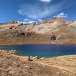
Ice Lake

Cappie’s Scoop: This trail was really cool! I hiked over a creek, past a waterfall, through the forest and then it opened up with some big meadows! Right before I started the tough climb up the mountain, I hopped over another creek. It was a tough hike but wow, when we saw that lake, it was the coolest color I’ve ever seen! It was very windy so Mom took a few photos and then we headed down. Don’t hesitate to add YOUR scoop in the comments below!
Tips: There are a number of amazing lakes in the Ice Lake Basin that you can hike to from this trailhead! There is even an option to do a bit of a loop to some of the lakes to include Island Lake, Ice Lake, and Fuller Lake. That route is about 8.6 miles with 3,070 ft elevation gain. You can also shorten this loop to hike just to Island Lake and Ice Lake which is about 7 miles with 2,650 ft elevation gain going clockwise. On this hike, we hiked to Ice Lake at 12,270 ft and back which is reflected in this post. Plus, dogs can be on leash or off-leash under voice control.
Directions: From the town of Silverton, head towards and turn slight right onto US-550 North. In about 2 miles, turn left onto Co Rd 7/Forest Rd 585. Continue down this dirt road passing dispersed camping sites and an established campground. The trailhead parking lot will be on your right in about 4.4 miles.
| Mileage (round trip) | 7 |
| Difficulty | Strenuous |
| Gain (in feet) | 2430 |
| Trailhead | 37.806673, -107.773987 |
| Hike Time (in hours) | 4-5 |
| Exposure | Sunny and Shady |
| Scenery | Mountain Views, Alpine Lake Views, Forest |
| Facilities | None |
| Fees/Permits | None |
| More Info | https://www.fs.usda.gov/recarea/sanjuan/recarea/?recid=42984&actid=50 |
| Last Hiked | 10/9/2020 |


